
Tropical Cyclone Lam makes landfall in north east NT

Tropical Cyclone Lam; from 16/02/2015 18:00 UTC to 19/02/2015 18:00 UTC
Updated 20 February 2015
Severe Tropical Cyclone Lam still dangerous but is expected to weaken to Category 2 later this morning.
Areas affected:
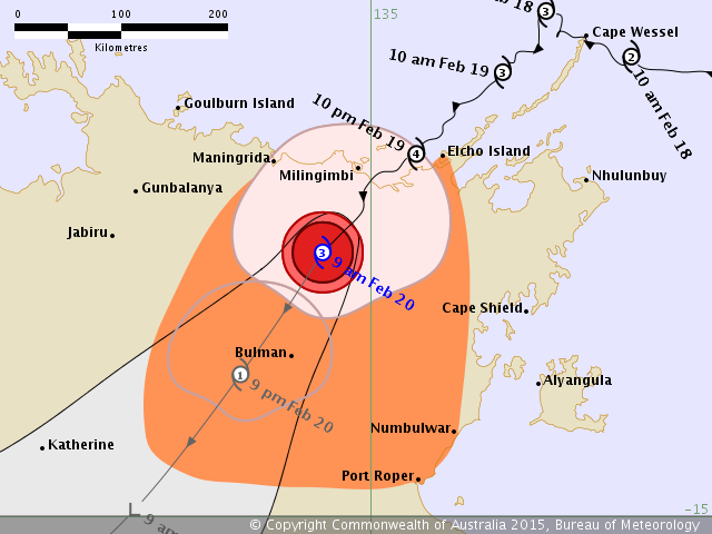
Warning zone: Maningrida to Elcho Island and Numbulwar to Port Roper, including inland areas to Bulman.
Details of Severe Tropical Cyclone Lam at 8:30 am CST:
Intensity: category 3, sustained winds near the centre of 120 kilometres per hour with wind gusts to 165 kilometres per hour.
Location: within 30 kilometres of 12.8 degrees South, 134.6 degrees East , 85 kilometres south southwest of Milingimbi and 135 kilometres southwest of Galiwinku .
Movement: south southwest at 13 kilometres per hour .
Severe Tropical Cyclone Lam crossed the mainland coast mid way between Milingimbi and Elcho Island at 2am this morning as a category 4 system.
The VERY DESTRUCTIVE core of Severe Tropical Cyclone Lam is now impacting inland areas of central Arnhem Land. Severe Tropical Cyclone Lam is expected to continue moving southwest and weaken today as it moves further inland.
Updated 19 February 2015
Severe Tropical Cyclone Lam shows signs of intensification. Gales at Elcho Island will increase to Destructive winds over next few hours
Areas affected:
Warning zone: Goulburn Island to Numbulwar, including Nhulunbuy, Groote Eylandt and adjacent inland areas to Bulman.
Watch zone: Numbulwar to Port Roper and adjacent inland areas.
Details of Severe Tropical Cyclone Lam at 1:30 pm CST:
Intensity: category 3, sustained winds near the centre of 140 kilometres per hour with wind gusts to 195 kilometres per hour.
Location: within 30 kilometres of 11.6 degrees South, 135.7 degrees East , 45 kilometres north northeast of Elcho Island and 135 kilometres west northwest of Nhulunbuy .
Movement: southwest at 10 kilometres per hour .
The VERY DESTRUCTIVE core of Severe Tropical Cyclone Lam is continuing to track southwest, parallel to the Wessel Islands and is expected to make landfall on the mainland coast between Milingimbi and Gapuwiyak overnight Thursday or Friday morning. Severe Tropical Cyclone Lam is then expected to weaken during Friday as it moves inland over Arnhem Land.
Hazards:
VERY DESTRUCTIVE winds with gusts greater than 170 kilometres per hour should continue over the Wessel Islands today and are expected to extend onto the mainland coast between Milingimbi and Gapuwiyak. VERY DESTRUCTIVE winds with gusts to 220 kilometres per hour may occur near the cyclone centre as it crosses the coast between Milingimbi and Gapuwiyak overnight Thursday to Friday morning.
DESTRUCTIVE winds with gusts to 130 kilometres per hour may develop about the mainland coast between Elcho Island and Gapuwiyak Thursday afternoon or evening before possibly extending west to Milingimbi and adjacent inland areas from Friday morning.
GALES with gusts to 110 kilometres are expected to devleop in coastal areas near Elcho Island during the next 6 hours and extend further east to Nhulunbuy and west to Milingimbi and adjacent inland areas later today and overnight. GALES may also extend as far west as Goulburn Island and inland to Bulman during Friday as the cyclone moves inland. GALES may extend further east to Groote Eylandt and inland areas including Numbulwar and Port Roper later on Friday depending on the track the cyclone takes.
Coastal residents between Milingimbi and Nhulunbuy, including Elcho Island, are specifically warned of a VERY DANGEROUS STORM TIDE as the cyclone centre approaches the coast on Thursday night and into Friday. Tides will rise significantly above the normal high tide, with DAMAGING WAVES and VERY DANGEROUS FLOODING.
HEAVY RAIN may cause flooding of low-lying areas in the northeast Top End on Thursday and Friday.
Updated 17 February 2015
Intensity: category 2, sustained winds near the centre of 95 kilometres per hour with wind gusts to 130 kilometres per hour.
Location: within 55 kilometres of 11.6 degrees South, 139.4 degrees East , 290 kilometres east northeast of Nhulunbuy and 415 kilometres northeast of Alyangula .
Updated 16 February 2015
A tropical cyclone is expected to develop in the northern Gulf of Carpentaria early Tuesday (17/02/2015).
A watch zone is in place from Badu Island to Cape Keerweer in Queensland and Nhulunbuy to Cape Shield including Groote Eylandt in the Northern Territory.