
Meteorology Basics
What is Meteorology? What is Weather? What is climate? What drives weather? The history of Meteorology Atmospheric Pressure systems
What is Meteorology?
The branch of science concerned with the processes and phenomena of the atmosphere, especially as a means of forecasting the weather. Meteorology is the interdisciplinary scientific study of the atmosphere.
The word 'meteor' is a variation on the Greek "meteoron", which is a term dealing with any objects that originate in the sky.
What is Weather?
Weather is the day-to-day conditions of any particular place. For example: It was raining today at work. Yesterday it was sunny at home.
Weather is the state of the atmosphere, to the degree that it is hot or cold, wet or dry, calm or stormy, clear or cloudy. Most weather phenomena occur in the troposphere, just below the stratosphere.
Weather generally refers to day-to-day temperature and precipitation activity, whereas climate is the term for the statistics of atmospheric conditions over longer periods of time. When used without qualification, "weather" is generally understood to mean the weather of Earth.
What is Climate?
Climate is quite different to weather. The climate is the common, average weather conditions at a particular place over a long period of time, generally more than 30 years.
For example, the climate of Sydney is generally sunny and warm. Sydney enjoys a sunny, Mediterranean-style climate all year round with more than 340 sunny days per year. Summers are warm to hot and winters are mild, with rainfall spread fairly evenly throughout the year.
Summer in Sydney is from December to February with average maximum temperatures around 26°C. It can also be humid at this time with an average humidity of 65 per cent. Average maximum temperatures in the winter months (June-August) are around 16°C. Sydney’s rainfall is highest between March and June.
What is Climate change?
Climate change, therefore, is a change in the typical or average weather of a region, town or city. This could be a change in the average annual rainfall, for example. Or it could be a change in a city's average temperature for a given month or season.
Climate change is also a change in Earth's overall climate. This could be a change in Earth's average temperature, for example. Or it could be a change in Earth's typical precipitation patterns.
What drives the weather?
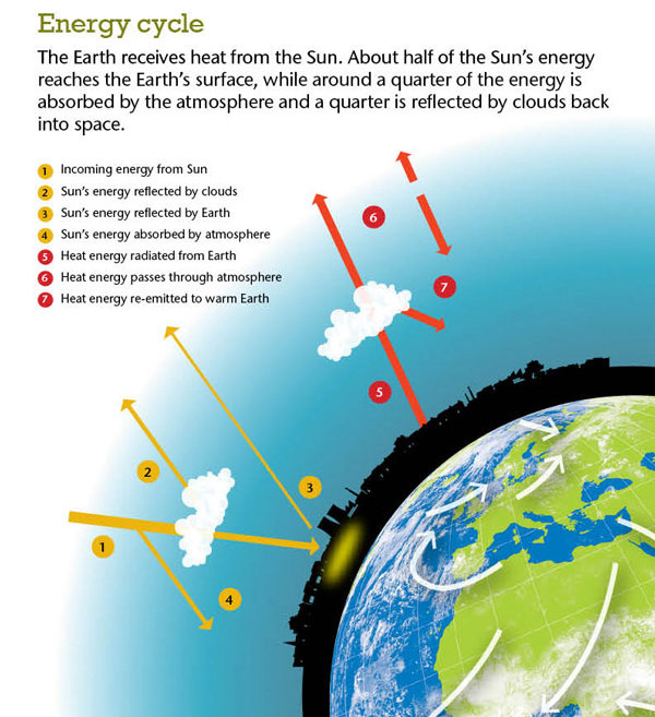
The sun is the driving force behind weather. As solar energy reaches the Earth, equatorial regions heat up more than the poles. The Earth’s main energy source is the sun. The sun causes convection within the atmosphere, which in turn affects weather and climate. The heating of the Earth’s surface and atmosphere by the sun drives convection within the atmosphere and ocean, producing winds and ocean currents.
As land or ocean water warms, it heats the air next to it and this air begins rising. As the heated air rises, air from elsewhere flows in to replace it. If the Earth were not rotating on its axis, the air flowing in to replace the rising air would be coming from the polar regions. At the same time, the air that rises near the equator would be flowing high above the ground, to descend and replace the air that's flowing along the surface toward the tropics.
Earth's rotation causes the air to begin turning as it flows along the ground or high in the air. The result is a complicated picture with extratropical storms carrying cold air toward the tropics and warm air toward the poles. Tropical cyclones carry warm air toward the poles. Warm and cold ocean currents also help balance the heat budget.
The History of Meteorology
Studies in the field stretch back millennia, though significant progress in meteorology did not occur until the 18th century.
The 19th century saw modest progress in the field after observing networks formed across several countries. It wasn't until after the development of the computer in the latter half of the 20th century that significant breakthroughs in weather forecasting were achieved.
Below from National geographic education:
The development of meteorology is deeply connected to developments in science, math, and technology. The Greek philosopher Aristotle wrote the first major study of the atmosphere around 340 BCE. Many of Aristotle’s ideas were incorrect, however, because he did not believe it was necessary to make scientific observations.
A growing belief in the scientific method profoundly changed the study of meteorology in the 17th and 18th centuries.
Evangelista Torricelli, an Italian physicist, observed that changes in air pressure were connected to changes in weather. In 1643, Torricelli invented the barometer, to accurately measure the pressure of air. The barometer is still a key instrument in understanding and forecasting weather systems. In 1714, Daniel Fahrenheit, a German physicist, developed the mercury thermometer. These instruments made it possible to accurately measure two important atmospheric variables.
There was no way to quickly transfer weather data until the invention of the telegraph by American inventor Samuel Morse in the mid-1800s. Using this new technology, meteorological offices were able to share information and produce the first modern weather maps. These maps combined and displayed more complex sets of information such as isobars (lines of equal air pressure) and isotherms (lines of equal temperature). With these large-scale weather maps, meteorologists could examine a broader geographic picture of weather and make more accurate forecasts.
In the 1920s, a group of Norwegian meteorologists developed the concepts of air masses and fronts that are the building blocks of modern weather forecasting. Using basic laws of physics, these meteorologists discovered that huge cold and warm air masses move and meet in patterns that are the root of many weather systems.
Military operations during World War I and World War II brought great advances to meteorology. The success of these operations was highly dependent on weather over vast regions of the globe. The military invested heavily in training, research, and new technologies to improve their understanding of weather. The most important of these new technologies was radar, which was developed to detect the presence, direction, and speed of aircraft and ships. Since the end of World War II, radar has been used and improved to detect the presence, direction, and speed of precipitation and wind patterns.
The technological developments of the 1950s and 1960s made it easier and faster for meteorologists to observe and predict weather systems on a massive scale. During the 1950s, computers created the first models of atmospheric conditions by running hundreds of data points through complex equations. These models were able to predict large-scale weather, such as the series of high- and low-pressure systems that circle our planet.
TIROS I, the first meteorological satellite, provided the first accurate weather forecast from space in 1962. The success of TIROS I prompted the creation of more sophisticated satellites. Their ability to collect and transmit data with extreme accuracy and speed has made them indispensable to meteorologists. Advanced satellites and the computers that process their data are the primary tools used in meteorology today.
Atmospheric Pressure Systems
Low-high pressure areas
A low pressure area is a region where the atmospheric pressure is lower than that of surrounding locations. A high pressure area, high or anticyclone is a
region where the atmospheric pressure at the surface of the planet is greater than its surrounding environment. Low-pressure areas have less atmospheric mass above their location,
whereas high pressure areas have more atmospheric mass above their location.
Winds within high-pressure areas flow outward from the higher pressure areas near their centres towards the lower pressure areas further from their centres.
Low-pressure systems form under areas of wind divergence which occur in upper levels of the troposphere.
Low Pressure Systems

At the surface, low pressure systems have a clockwise rotation in the Southern Hemisphere, with the wind turning slightly inward towards the lowest pressure.
This causes air to converge, or come together, at the centre of the low near the ground. The converging air has nowhere else to go so it rises.
As the air rises, the water vapour within cools and eventually condenses into cloud droplets and raindrops. Because of this, low pressure centres are generally associated with clouds, precipitation, and what we generally call bad weather.
High Pressure Systems

Surface high pressure systems in the Southern Hemisphere have a anti-clockwise rotation with wind turning slightly outward away from the highest pressure.
This causes air to diverge, or move away, from the centre of the high near the ground. Air has to come from above to fill in the void left by the diverging air at the surface.
This leads to sinking motion in the centre of a high pressure system and generally clear air. This explains why high pressure systems are associated with what we think of as good weather.
Resource: "What is meteorology" and "History of meteorology"modified from https://en.wikipedia.org/wiki/Meteorology
"What is weather" modified from https://en.wikipedia.org/wiki/Weather.