
Tropical Cyclone Neville

Severe Tropical Cyclone Neville spent two weeks traversing the eastern Indian Ocean as a tropical low before developing into a tropical cyclone as it moved west and away from the Western Australian mainland. Although no land impacts were experienced, heavy monsoonal conditions affected both the Cocos (Keeling) Islands and Christmas Island as it moved past.
A tropical low (08U) formed in the Indian Ocean on 4 March, about 500 km WNW of the Cocos (Keeling) Islands. The low was slow moving and remained weak until 8 March, when it started moving towards the east to southeast under the influence of an increasing monsoonal flow to the north. The system struggled to develop significantly in these early stages due to the effects of strong vertical wind shear in the atmosphere. However, an increasing monsoonal flow saw gale force winds develop on the northwest quadrant of the system during 9 March, which then extended to the northeast quadrant on 10 March.
While still a low, Neville passed close to the Cocos (Keeling) Islands on 10 March, with near-gale force winds being recorded at Cocos Island Airport on 10-11 March. The peak wind gust recorded was 83 km/h at 1830 UTC 10 March and some structural damage occurred at the Island's resort. The monsoonal flow strengthened further after this, which accelerated the low faster towards the east southeast from 11 March. Although it passed more than 250 km to the south of Christmas Island on 12 March, large waves caused inundation and damage along the Island's northern coast.
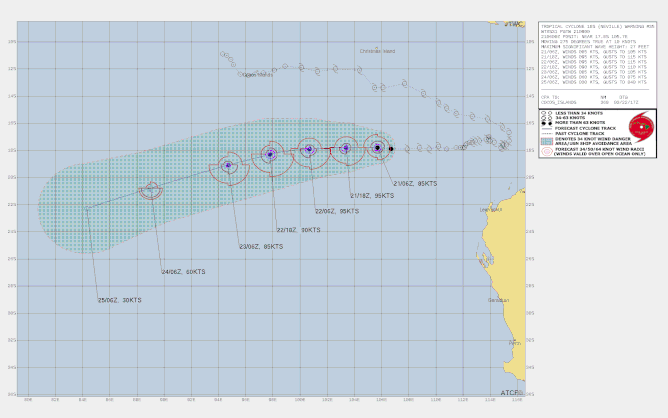
By 14 March the low was located northwest of the WA coast, and at this stage the monsoonal flow weakened, and gales were no longer observed. It remained slow moving over the next few days as a mid-level trough to the south resulted in light steering winds. The low began moving towards the west from 19 March due to the influence of a mid-level ridge to the south. At the same time, it encountered an area of favourable environmental conditions which led to development, and the system was named Tropical Cyclone Neville at 0600 UTC 20 March (2pm AWST).
Tropical Cyclone Neville continued to rapidly develop into a severe tropical cyclone and reached a peak 10-minute mean wind intensity of 175 km/hr at 0000 UTC 22 March (8am AWST).
From later on 22 March, Severe Tropical Cyclone Neville began to weaken under the influence of dry air and increasing vertical wind shear. It dropped below tropical cyclone intensity at 8pm AWST 24 March (1200 UTC), as it passed into the La Reunion RSMC Area of Responsibility. It then dissipated in the early hours of 26 March.
Severe Tropical Cyclone Neville was the fifth tropical cyclone of the Australian 2023-4 season, and the fourth to reach severe intensity.
From www.bom.gov.au
Track Maps

Satellite Images

