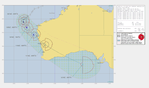
Tropical Cyclone Seroja

Tropical cyclone Seroja developed from a tropical low pressure system on 5 April 2021 in the Indian Ocean off the North Western Australia coast. Seroja was a slow moving system moving to the southwest along the WA coast. Tropical Cyclone Seroja developed to a category 3 system and increased in speed to 26 km/h while turning towards the Western Australia coast. Seroja continue southwesterly and crossed the WA coast on Sunday April 11 2021 as a category 3 cyclone between Carnarvon and Jurien Bay.
Headline:
Tropical Cyclone Seroja is moving towards the southeast. Dangerous weather expected to develop on the west coast from Sunday afternoon.
Areas Affected:
Warning Zone
Minilya Roadhouse to Lancelin along the coast, extending to inland areas including Mount Magnet, Dalwallinu and Paynes Find.
Watch Zone
Inland areas including Merrredin and Southern Cross.
Details of Tropical Cyclone Seroja at 5:00 am AWST 11/04/2021:
Intensity: category 2, sustained winds near the centre of 110 kilometres per hour with wind gusts to 155 kilometres per hour.
Location: within 55 kilometres of 23.5 degrees South, 110.0 degrees East , 405 kilometres west northwest of Carnarvon and 630 kilometres northwest of Kalbarri .
Movement: southeast at 26 kilometres per hour .
Tropical Cyclone Seroja is moving towards the southeast and approaching the west coast of WA.
Seroja is expcted to intensify to Severe Category 3 intensity as it accelerates southeastwards towards the coast. It is then forecast to weaken back to Category 2 before it crosses the coast. The cyclone should weaken further as it moves inland on Monday but is still likely to be causing gusty winds east and north of the track, and heavy rain close to the track, as it crosses over the south of the state.
Hazards:
GALES with gusts to 100 kilometres per hour are likely to develop in an area between Minilya Roadhouse and Kalbarri during Sunday afternoon, then extend further south towards Lancelin and inland into the southern Gascoyne and the Central Wheatbelt during Sunday evening and early on Monday morning.
DESTRUCTIVE WINDS with gusts to 150 kilometres per hour are forecast to occur close to the centre of Seroja as it moves across the coast and into adjacent inland parts. The most likely area to experience destructive wind gusts is on the coast between Geraldton and Denham. People near Denham may see gales as early as midday on Sunday, tending to as early as dusk further south near Geraldton. The most likely time for onset of gales winds is mid to late Sunday afternoon near Denham, and during Sunday evening or overnight near Kalbarri and Geraldton.
Seroja will be moving fast, so weather conditions will deteriorate rapidly as it approaches.
HEAVY TO INTENSE RAINFALL and FLASH FLOODING are likely close to the track of Seroja during Sunday and Monday.
ABNORMALLY HIGH TIDES could cause minor inundation at the coast between Coral Bay and Lancelin, increasing to SERIOUS FLOODING in the Denham and Shark Bay region and near Kalbarri. Dangerous surf and beach erosion is expected between Denham and Geraldton.
Details of Tropical Cyclone Seroja at 2:00 am AWST 11/04/2021:
Intensity: Category 2, sustained winds near the centre of 110 kilometres per hour with wind gusts to 155 kilometres per hour.
Location: within 55 kilometres of 22.4 degrees South 109.6 degrees East, estimated to be 500 kilometres west northwest of Carnarvon and 750 kilometres northwest of Kalbarri.
Movement: southeast at 24 kilometres per hour.
Tropical Cyclone Seroja is moving towards the southeast and approaching the west coast of WA.
Seroja is expected to intensify a little during Sunday, possibly reaching Severe Category 3 intensity as it accelerates southeastwards towards the coast. It is then forecast to weaken back to Category 2 before it crosses the coast.
The cyclone should weaken as it moves inland on Monday but is still likely to be causing gusty winds east and north of the track, and heavy rain close to the track, as it crosses over the south of the state.
Hazards:
GALES with gusts to 100 kilometres per hour are likely to develop in an area between Minilya Roadhouse and Kalbarri during Sunday afternoon, then extend further south towards Lancelin and inland into the southern Gascoyne and the Central Wheatbelt during Sunday evening and early on Monday morning.
DESTRUCTIVE WINDS with gusts to 150 kilometres per hour are forecast to occur close to the centre of Seroja as it moves across the coast and into adjacent inland parts. The most likely area to experience destructive wind gusts is on the coast between Geraldton and Denham. People near Denham may see gales as early as midday on Sunday, tending to as early as dusk further south near Geraldton. The most likely time for onset of gales winds is mid to late Sunday afternoon near Denham, and during Sunday evening or overnight near Kalbarri and Geraldton.
Seroja will be moving fast, so weather conditions will deteriorate rapidly as it approaches.
HEAVY TO INTENSE RAINFALL and FLASH FLOODING are likely close to the track of Seroja during Sunday and Monday.
ABNORMALLY HIGH TIDES could cause minor inundation at the coast between Coral Bay and Lancelin, increasing to SERIOUS FLOODING in the Denham and Shark Bay region and near Kalbarri. Dangerous surf and beach erosion is expected between Denham and Geraldton.
Recommended Action:
DFES advises of the following community alerts effective as of 6:00 PM Saturday:
YELLOW ALERT: People in or near Carnarvon to Kalbarri, not including Kalbarri townsite, need to take action and get ready to shelter from a cyclone.
BLUE ALERT: People in or near Cape Cuvier to Lancelin, including Cape Cuvier and Lancelin, and extending inland to include the Shires of Northampton, Chapman Valley, Morawa, Greater Geraldton, Mingenew, Three Springs, Perenjori and the townsites of Mullewa, Coorow and Carnamah need to prepare for cyclonic weather and organise an emergency kit including first aid kit, torch, portable radio, spare batteries, food and water.
ALL CLEAR: People in communities Coral Bay to Cape Cuvier are advised that wind and storm surge dangers have passed but you need to take care to avoid the dangers caused by damage.
People needing SES assistance can call 132 500. In a life-threatening situation call 000. For more safety tips visit www.emergency.wa.gov.au
Communities within the Yellow and Blue Alert areas above should listen for the next advice.
Next Advice:
The next advice will be issued by 6:00 am AWST Sunday 11 April.
Details of Tropical Cyclone Seroja at 2:00 am AWST 10/04/2021:
Intensity: category 2, sustained winds near the centre of 95 kilometres per hour with wind gusts to 130 kilometres per hour.
Location: within 45 kilometres of 20.5 degrees South, 108.4 degrees East , 630 kilometres west northwest of Coral Bay and 730 kilometres northwest of Carnarvon .
Movement: southwest at 11 kilometres per hour .
Tropical Cyclone Seroja (category 2) continues to track to the southwest over open waters well to the west of the North West Cape. Seroja will continue to intensify today as it begins to move south possibly reaching severe category 3 on Saturday night. During Sunday the system accelerates while taking a southeast track and weakening slightly as it approaches the central west coast. Weather conditions will change and deteriorate rapidly near the west coast on Sunday as Seroja approaches the coast, making landfall late Sunday or early Monday between Carnarvon and Jurien Bay. The cyclone should gradually weaken as it moves inland on Monday but still likely to be causing gusty winds east and north of the track.
Hazards: GALES with gusts to 100 kilometres per hour are likely to develop in an area between Coral Bay and Kalbarri during Sunday. Gales will extend further south towards Lancelin and inland into the Gascoyne and northern Wheatbelt later Sunday and then further inland to the southern Goldfields during Monday. DESTRUCTIVE WINDS with gusts to 150 kilometres per hour are forecast to occur closer to the centre of Seroja as it moves across the coast and into adjacent inland parts. HEAVY TO INTENSE RAINFALL and FLASH FLOODING are likely close to the track of Seroja during Sunday and Monday. ABNORMALLY HIGH TIDES could cause minor flooding at the coast between Coral Bay and Lancelin, increasing to be SERIOUS FLOODING in the Denham and Shark Bay region.
12 April 2021
Details adapted from www.bom.gov.au