Tropical Cyclone Lucas
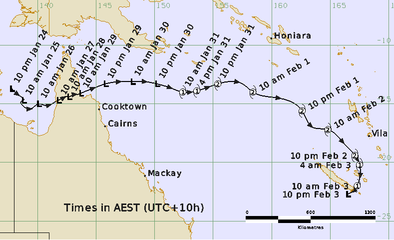
A tropical low in the western Gulf of Carpentaria on 24 January intensified slowly on 25 and 26 January 2021. The low remained below tropical cyclone strength as it made landfall on western Cape York Peninsula coast on 26 January. The low took two days to cross the Cape York Peninsula, during which it lost all its structure and cloud signatures. Once it moved over the northwest Coral Sea region, it began redeveloping due to favorable environment. The low reached tropical cyclone strength on 31 January. Lucas intensified quickly to a category 2 system while continuing to move eastwards across the Coral Sea south of the Solomon Islands. Lucas maintained category 2 intensity as it moved out of the region on 1 February. The system began to weaken the next day as it turned southeast across southern Vanuatu and crossed the southern tip of New Caledonia on 3 February 2021. Immediately, after encountering land, Lucas weakened below cyclone strength.
Details of Tropical Cyclone Lucas at 4:00 pm AEST 31 January 2021:
Intensity: category 1, sustained winds near the centre of 65 kilometres per hour with wind gusts to 95 kilometres per hour.
Location: within 55 kilometres of 13.9 degrees South, 153.1 degrees East , 430 kilometres northeast of Willis Island and 870 kilometres east northeast of Cooktown.
Movement: east at 13 kilometres per hour .
Tropical cyclone Lucas is expected to continue moving eastwards while intensifying further.
Hazards: The cyclone is expected to remain well to the east of the Queensland coast with no impact on mainland or coastal communities.
31 January 2021
Adapted from www.bom.gov.au