Tropical Cyclone Niran
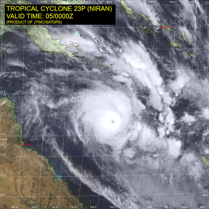
Tropical cyclone Niran developed from a tropical low pressure system on 2 March 2021 in the Coral sea off the north Queensland coast near Cairns. Niran was a slow moving system and stayed in the region up to March 4 when it developed further to a Severe Tropical Cyclone while speeding up and moving to the southeast away from the coast. Severe Tropical Cyclone Niran continued to develop into a category 4 Severe Tropical Cyclone before degrading near Noumea.
TROPICAL CYCLONE INFORMATION BULLETIN
Issued at 4:59 pm EST on Friday 5 March 2021
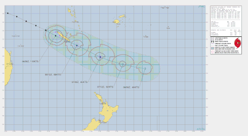
At 4 pm AEST Friday, Severe Tropical Cyclone Niran (Category 4) with central pressure 944 hPa was located over the Coral Sea near latitude 17.7 south
longitude 156.9 east, which is about 750 km east southeast of Willis Is and 890 km east northeast of Mackay. Niran is forecast to intensify this evening as it accelerates to the east southeast, continuing to move away from the Queensland coast and towards New Caledonia. It is expected to weaken from Saturday, continuing a rapid east southeast track.
No direct hazards are expected about Queensland coastal or island communities.
Details of Tropical Cyclone Niran at 4:00 pm AEST, 03/03/2021:
Intensity: Category 2, sustained winds near the centre of 110 kilometres per hour with wind gusts to 155 kilometres per hour.
Location: within 30 kilometres of 14.8 degrees South 147.9 degrees East, estimated to be 325 kilometres northeast of Cairns and 300 kilometres east northeast of Cooktown.
Movement: slow moving.
Tropical cyclone Niran has been moving very slowly in the past 24 hours. While it may remain slow-moving tonight, the cyclone is expected to adopt a southeasterly track on Thursday as it accelerates further away from the coast.
As the cyclone continues to remain slow-moving and intensifies tonight, it may produce gales about exposed coastal and island communities between Cape Flattery and Innisfail tonight or early on Thursday.
Hazards:
GALES with gusts to 100km/h may develop about exposed coastal and island communities between Cape Flattery and Innisfail - including Cooktown, Port Douglas, and Cairns - tonight or early on Thursday as the cyclone intensifies.
Recommended Action:
People between Cape Flattery and Innisfail, including Cooktown, Port Douglas, and Cairns, should take precautions and listen to the next advice at 8pm AEST.
- Information is available from your local government
- For cyclone preparedness and safety advice, visit Queensland's Disaster Management Services website (www.disaster.qld.gov.au)
- For emergency assistance call the Queensland State Emergency Service (SES) on 132 500 (for assistance with storm damage, rising flood water, fallen trees on buildings or roof damage).
Details of Tropical Cyclone Niran at 4:00 pm AEST, 02/03/2021:
Tropical cyclone Niran, category 2, lies off the north Queensland coast.
Areas affected:
Warning zone: Cape Flattery to Innisfail.
Watch zone: Cape Melville to Cape Flattery and Innisfail to Lucinda.
Intensity: category 2, sustained winds near the centre of 95 kilometres per hour with wind gusts to 130 kilometres per hour.
Location: within 35 kilometres of 14.7 degrees South, 147.7 degrees East , 320 kilometres northeast of Cairns and 275 kilometres east northeast of Cooktown .
Movement: north northeast at 8 kilometres per hour .
Tropical cyclone Niran is expected to remain slow-moving off the north Queensland coast while gradually intensifying over the next two days.
Coastal crossing of the cyclone is not expected. However, as the cyclone develops or if it drifts slightly westwards, then it may cause gales about the exposed coastal and island communities on Wednesday.
From Thursday onwards, the cyclone is expected to take a southeasterly track, away from the coast.
06 March 2021
Details adapted from www.bom.gov.au