Tropical Cyclone Gita whips up large swells on the east coast of Australia


Wave height and wave period at the Gold Coast wave monitoring buoy. Image from www.qld.gov.au/waves.

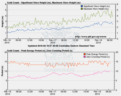
Large and consistent swell are arriving on the east coast of Australia between 16 and 20 February. The swell originated from the severe wind speeds of Tropical Cyclone Gita. TC Gita developed into a category 5 Tropical Cyclone in the south west Pacific ocean on 14 February 2018 and moved towards the Australian coast. the forecast track for TC Gita takes it southward through the Coral Sea before turning south easterly towards New Zealand. 

Colourised satellite image of Tropical Cyclone Gita as a category 2 Tropical Cyclone. Image from NOAA
Wave Spectra off the East coast of Australia near Brisbane (in water 70m deep) generated by Tropical Cyclone Gita on February 18 2018.  Image from qld.gov.au/waves.
Wave Spectra off the East coast of Australia near Brisbane (in water 70m deep) generated by Tropical Cyclone Gita on February 18 2018. Image from qld.gov.au/waves.
Forecast track map of Tropical Cyclone Gita, 17 February 2018. Image from Fiji Meterological Service.