Tropical Cyclone Oma
Tropical cyclone Oma persisted in the Coral Sea as a tropical cyclone for eleven days. Oma caused gale force winds, abnormally high tides and large surf about the southeast Queensland coast, northern New South Wales coast and Lord Howe Island. Significant beach erosion occurred along the southeast Queensland and northern New South Wales coasts and there was one reported drowning fatality off North Stradbroke Island during the event.
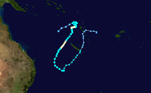
The tropical low that became Oma was first identified in the northern Coral Sea, west of Vanuatu, on 11 February 2019. The system initially tracked in an eastwards direction and formed into a tropical cyclone near Vanuatu late on 12 February. Oma intensified to category 2 strength on 13 February and became slow-moving to the northwest of Vanuatu for several days. By 18 February, Oma started to steer towards the southwest and for a brief period the system reached category 3 strength to the west of New Caledonia on 19 and 20 February.
As Oma started to move into the southern Coral Sea on 22 February it began to lose some of its tropical characteristics and by 23 February the system was transitioning into a subtropical cyclone, around 400 kilometres northeast of Lord Howe Island. Although Oma remained well offshore in the Coral Sea, damaging to locally destructive winds occurred about the southeast Queensland coast, northern New South Wales coast and Lord Howe Island on 22 and 23 February. These winds were due to an extensive area of gale force winds that developed to the south of the system as it interacted with a firm subtropical ridge across the Tasman Sea.
At one stage during the event, there was a credible risk of Oma tracking close to the southeast Queensland coast and as a result a Tropical Cyclone Watch was issued for coastal areas between Bundaberg (Qld) and Ballina (NSW). This watch area included Brisbane, which made it the first one issued for the capital city in at least twenty years. The watch was current for just under a day and was cancelled once it became evident that Oma was starting to veer away from the Australian east coast.
Significant wind gusts recorded during the event included 144 km/h at Lord Howe Island Windy Point, 113 km/h at Cape Moreton, 109km/h at Double Island Point, 100 km/h at Cape Byron and 89 km/h at Gold Coast Seaway.
Maximum wave heights of around 13 metres were recorded at Mooloolaba and off Point Lookout during the event, which were greater than those recorded during cyclone Oswald in 2013. Maximum wave heights of 11.4 metres were also recorded at Byron Bay.
Extreme values during cyclone event (estimated)
Note that these values may be changed on the receipt of later information
Maximum Category: 3
Maximum sustained wind speed: 130 km/h
Maximum wind gust: 185 km/h
Lowest central pressure: 966 hPa
From: http://www.bom.gov.au/announcements/sevwx/qld/qldtc20190212.shtml