
Tropical Cyclone Nora
Tropical Cyclone Nora formed to the north of Nhulunbuy on 22 March 2018. Tropical Cyclone Nora moved eastwards and will begin a more southeasterly path during 23 March and Saturday into the Gulf of Carpentaria. The system reached Category 3 during the 23rd and reach.
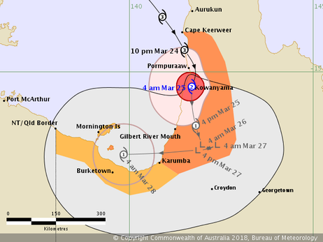
Nora made a coastal crossing near Pomporrow along the western Cape York Peninsula on the 24 March. Tropical Cyclone Nora as a Category 2 cyclone, tracked southwards over land near the western Cape York Peninsula coast before weakening to a tropical low.
Ex-tropical cyclone Nora is slowly moving down the west coast of Cape York, near Gilbert River Mouth. On the current forecast track, ex-tropical cyclone Nora is expected to move back over southeast Gulf of Carpentaria waters during Monday and if this were to occur it is possible that it could reform back into a tropical cyclone by Tuesday. However, given the forecast track of Nora is quite close to the coast, the possibility of it moving back over water sooner cannot be ruled out.
Intensity: Tropical Low, sustained winds near the centre of 55 kilometres per hour with wind gusts to 95 kilometres per hour.
Location: within 55 kilometres of 16.6 degrees South 141.3 degrees East, estimated to be 115 kilometres north northeast of Karumba and 230 kilometres east of Mornington Island.
Movement: south at 9 kilometres per hour.
From www.bom.gov.au.


