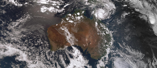
Tropical Cyclone Tiffany
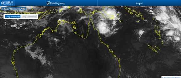
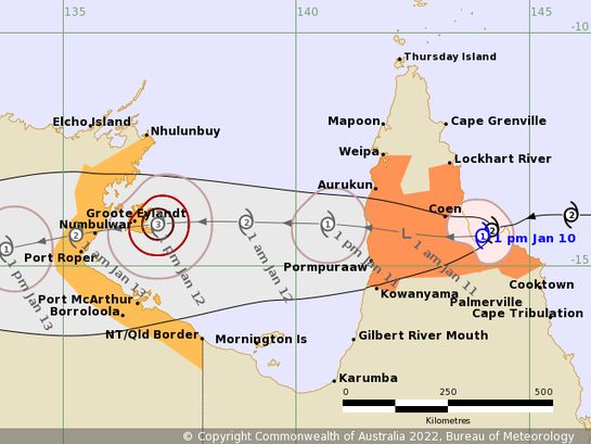
A tropical low pressure system developed into a Tropical Cyclone off the far north Queensland coast northeast of Cooktown on Sunday 9 January 2022 (4pm). After making landfall north of Cooktown as a category 2 cyclone Tiffany downgraded to a tropical low pressure system on Monday January 10 2022. Ex-tropical Cyclone Tiffany continued to move across Cape Yorke peninsula and into the Gulf of Carpentaria on the 11th January. The system is forecast to continue moving across the Gulf and develop again (a zombie cyclone) to a tropical cyclone and making landfall on the Northern Territory coast.
From www.bom.gov.au
Details of Tropical Cyclone Tiffany at 4:00 pm AEST 09/01/2022:
Intensity: category 1, sustained winds near the centre of 75 kilometres per hour with wind gusts to 100 kilometres per hour.
Location: within 35 kilometres of 13.9 degrees South, 146.7 degrees East , 235 kilometres northeast of Cooktown and 390 kilometres east southeast of Lockhart River .
Movement: west at 11 kilometres per hour .
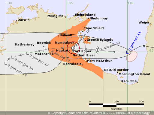
Tropical Cyclone Tiffany (Category 1) has rapidly developed in the last 24 hours. Tiffany will continue to intensify is it approaches the far north Queensland coast, making landfall between Cooktown and Lockhart River. Timing of landfall will depend on whether Tiffany moves south or north of Cape Melville. After weakening over land, the system is then expected to continue moving west into the Gulf of Carpentaria on Tuesday and re-intensify quickly as it moves towards the Northern Territory coast. A severe tropical cyclone coastal impact on the NT coast is possible on Wednesday or Thursday.
Hazards:
GALES with gusts to 110 km/h developing between Cape Tribulation and Coen including Cooktown early Monday as Tiffany approaches the coast. DESTRUCTIVE wind gusts to 130 km/h are possible near the system centre on Monday as it approaches the coast. Gales may extend north to Cape Grenville including Lockhart River later on Monday. Gales with gusts to 100 km/h may develop on the western Cape York Peninsula between Kowanyama and Mapoon, including Weipa, for a period on Tuesday.
HEAVY RAIN is expected to accompany the system as it moves across Cape York Peninsula.
As the system crosses the coast, abnormally high tides are expected between Cooktown and Lockhart River, but the sea level should not exceed the highest tide of the year. Large waves are likely along the beachfront. Abnormally high tides are also expected on the western Cape York Peninsula during Tuesday and Wednesday.
Recommended Action:
People between Cape Tribulation and Coen including Cooktown, should immediately commence or continue preparations, especially securing boats and property using available daylight hours.
People between Cape Grenville and Coen including Lockhart River should take precautions and listen to the next advice at 8pm.
People between Mapoon and Kowanyama including Weipa should consider what action they will need to take if the cyclone threat increases.
- Information is available from your local government
- For cyclone preparedness and safety advice, visit Queensland's Disaster Management Services website (www.disaster.qld.gov.au)
- If you choose to take shelter away from your home, stay COVID-19 safe and pack a mask and hand sanitiser (if you have them).
- For emergency assistance call the Queensland State Emergency Service (SES) on 132 500 (for assistance with storm damage, rising flood water, fallen trees on buildings or roof damage).
Details:
Time (AEST) Intensity Category Latitude
(decimal deg.) Longitude
(decimal deg.) Estimated Position
Accuracy (km)
0hr 4 pm January 9 1 13.9S 146.7E 35
+6hr 10 pm January 9 1 13.8S 146.2E 70
+12hr 4 am January 10 1 13.9S 145.5E 95
+18hr 10 am January 10 2 14.0S 144.9E 105
+24hr 4 pm January 10 2 14.1S 144.4E 115
+36hr 4 am January 11 tropical low 14.2S 142.7E 140
+48hr 4 pm January 11 1 14.2S 141.1E 175
+60hr 4 am January 12 1 14.1S 139.0E 195
+72hr 4 pm January 12 2 14.2S 137.3E 200
Tropical Cyclone information is also available in MetEye
From www.bom.gov.au