Tropical Cyclone Odette

Tropical cyclone Odette developed from a tropical low pressure system on 8 April 2021 in the Indian Ocean off the north Western Australia coast. Odette weakened to a tropical low due to exposure to wind shear and was incorporated into the larger Tropical Cyclone Seroja system (the Fujiwhara Effect). The system moved to the southwest while rotating around TC Seroja.
TROPICAL CYCLONE INFORMATION BULLETIN
Issued at 8:23 am WST on Saturday 10 April 2021
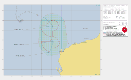
Ex-Tropical Cyclone Odette was located at 8:00 am AWST near 18.9S 112.8E,that is 365 km north northwest of Exmouth and 485 km north northwest of Coral Bay and moving south southeast at 35 kilometres per hour. Ex-Tropical Cyclone Odette is moving rapidly to the south and forecast to remain off the northwest coast. By Sunday the system is likely to have dissipated over waters west of the Gascoyne coast.
DAMAGING WINDS with gusts in excess of 90 kilometres per hour may develop
between Exmouth and Coral Bay during this afternoon and evening. Refer to
Severe Weather Warning for details. Although rainfall is expected to increase for a period today about the west
Pilbara coast, significant rainfall totals and flash flooding are not expected.
Details of Tropical Cyclone Odette at 2:00 am AWST Saturday 10 April 2021:
Intensity: category 1, sustained winds near the centre of 75 kilometres per hour with wind gusts to 100 kilometres per hour.
Location: within 30 kilometres of 17.1 degrees South, 112.1 degrees East , 580 kilometres north northwest of Exmouth and 700 kilometres north northwest of Coral Bay .
Movement: southeast at 32 kilometres per hour .
Tropical Cyclone Odette is located well to the northwest of the WA mainland and northeast of Tropical Cyclone Seroja. Odette is forecast to move towards the south-southeast early Saturday morning before rapidly tracking to the south-southwest later on Saturday, passing to the west of the Pilbara. Tropical Cyclone Odette is only expected to be a short-lived system as it is expected to weaken during its interaction with Tropical Cyclone Seroja during Saturday. By Sunday the system is likely to have dissipated over waters west of the Gascoyne coast. Although Tropical Cyclone Odette is likely to weaken below tropical cyclone intensity before passing to the west of the Pilbara, there is the risk of a period of damaging winds and rain developing between Exmouth and Coral Bay during Saturday afternoon and evening.
A Severe Weather Warning is in place for the west Pilbara and northwest Gascoyne, refer to http:/www.bom.gov.au/wa/warnings/ for latest details.
Hazards:
DAMAGING WINDS with gusts in excess of 90 kilometres per hour may develop between Exmouth and Coral Bay during Saturday afternoon and evening. Although rainfall is expected to increase during Saturday about the west Pilbara coast, significant rainfall totals and flash flooding are not expected.
10 April 2021
Details adapted from www.bom.gov.au