
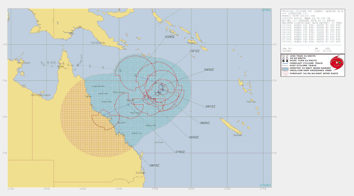
Tropical Cyclone Penny
Tropical Cyclone Penny re-formed in the Coral Sea.
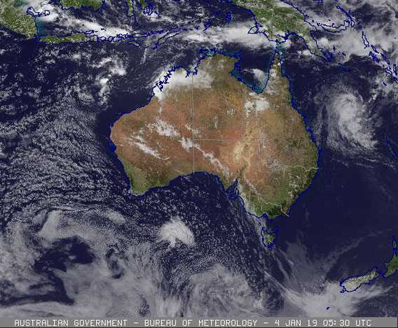
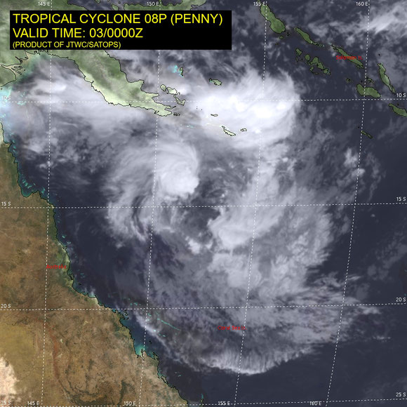
The second cyclone to develop in the Australian region in the 2018-19 season has been named Penny. TC Penny formed at around 7am on new years day 2019 in the Gulf of Carpentaria.
Penny developed into a category 2 cyclone while moving towards the eastern side of the gulf and making landfall just south of Weipa at around 10am.
The system was degraded to a tropical low, while moving over Cape Yorke Peninsular and into the Coral Sea. Ex-TC Penny continued to move Eastward while the conditions for re-genesis became favorable. At around 4pm on 2 January 2019 Tropical Cyclone returned to life (reformed) and continued moved towards the South East as.a category 2 cyclone. Penny turned back towards the Queensland coast, conditions were not favorable for further devlopement.


Details of Tropical Cyclone Penny at 7:00 am AEST 1 January 2019
Intensity: category 1, sustained winds near the centre of 75 kilometres per hour with wind gusts to 100 kilometres per hour.
Location: within 35 kilometres of 12.7 degrees South, 140.9 degrees East , 110 kilometres west of Weipa and 115 kilometres northwest of Aurukun .
Movement: east southeast at 8 kilometres per hour .
Tropical cyclone Penny has formed in the eastern Gulf of Carpentaria. Penny is expected to move east towards Cape York Peninsula and cross the coast near Weipa this afternoon as a category 1 system. The cyclone may reach category 2 if it moves slower than expected and spends more time over water.
Hazards:
GALES, with peak gusts in excess of 90km/h, are occurring on the western Cape York Peninsula coast between Mapoon and Aurukun, and may extend to remaining areas between Cape York and Pormpuraaw later today. Isolated damaging wind gusts may occur otherwise with monsoonal thunderstorms over the Torres Strait Islands, and a separate Severe Weather Warning is current for these conditions.
HEAVY RAINFALL, which may lead to flash flooding, is likely across Cape York Peninsula and parts of the North Tropical Coast today and Wednesday.
A Flood Watch remains current for coastal catchments north of Cardwell, including catchments across the Cape York Peninsula. A separate Severe Weather Warning is also current for rainfall on the northeast tropical coast.
TIDES will be higher than normal through Torres Strait and along the northwest Cape York Peninsula over the next couple of days.
As the cyclone approaches the coast, a storm tide is expected between Cape York and Cape Keerweer. Large waves may produce minor flooding along the foreshore. People living in areas likely to be affected by this flooding should take measures to protect their property as much as possible and be prepared to help their neighbours.
Technical details 31 December 2018
The tropical low is tracking in a westwards direction across the Gulf of
Carpentaria and is situated along a strengthening monsoon trough, which extends
from the northern Gulf of Carpentaria to the Coral Sea. Weipa radar shows broad
rotation around the LLCC and as a result there is a fair degree of confidence in
the location of the centre. The current westwards motion is mainly due to low to
middle level steering due to a high pressure system in the Tasman Sea, though as
the system deepens it is expected to adopt a track back towards the west coast
of Cape York Peninsula overnight as the monsoon strengthens across the northern
Gulf of Carpentaria and Coral Sea.
The tropical low is located north of the upper ridge, with good outflow to the
northwest and southwest. However shear is estimated at 20-30 knots and is
evident by the deepest convection displaced west of the low level centre. Recent
satellite imagery shows convection developing near the low centre and weak
curvature in the deep convection to the west. Dvorak analysis of T2.0 based on a
0.3 wrap. MET=1.5, adjusted to 2.0 by pattern.
Forecast intensity is based on a standard development. Wind shear is lower along
the forecast path. Maximum intensity is forecast at 45 knots before landfall on
the west coast of Cape York Peninsula but category 2 remains a possibility if
the system spends more time over water. The system is expected to weaken below
TC intensity as it crosses Cape York Peninsula but may re-intensify into a TC
over the Coral Sea later this week.