Tropical Cyclone Megan

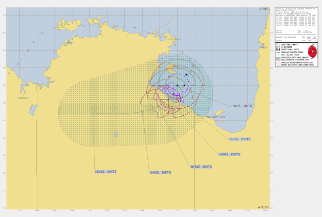
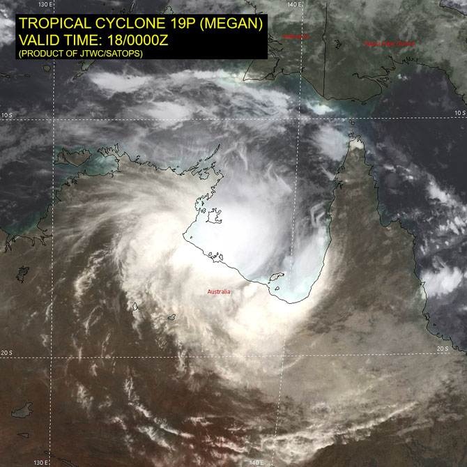
Tropical Cyclone Megan developed on the western side of the Gulf of Carpentaria on March 16 2024. Megan developed to a category 3 Severe Tropical Cyclone on March 17. Megan moved south in the gulf towards the southern gulf coast and made landfall on Monday March 18 in the Northern Territory.
Tropical Cyclone Megan 09U
Megan made landfall at 3:30 pm ACST southwest of Port McArthur on the southwestern Gulf of Carpentaria and is forecast to slowly move inland overnight and weaken.
Megan is forecast to weaken below cyclone intensity during Tuesday and then move west across the Northern Territory towards the Kimberley as a tropical low. It is not expected to redevelop into a tropical cyclone even though it may approach the west Kimberly coast late in the week.
Last updated, 05:01 pm AEST, March 18 2024.
Headline:
Megan is located inland of the southwestern Gulf of Carpentaria coast and will continue to cause an extended period of damaging winds to communities near the track overnight.
Areas affected:
Warning zone: Port Roper (NT) to Mornington Island in Qld (not including Mornington Island), extending inland to Borroloola, McArthur River Mine, and Robinson River, but not including Ngukurr.
Watch zone: None.
Cancelled zones: None.
Details of Severe Tropical Cyclone Megan at 6:30 pm ACST March 18:
Intensity: category 3, sustained winds near the centre of 120 kilometres per hour with wind gusts to 165 kilometres per hour.
Location: within 35 kilometres of 16.1 degrees South, 136.8 degrees East , 60 kilometres east of Borroloola and 45 kilometres southeast of Port McArthur .
Movement: south southwest at 7 kilometres per hour .
Severe Tropical Cyclone Megan made landfall at 3:30 pm ACST on the southwestern Gulf of Carpentaria coast southeast of Port McArthur. Megan will now move slowly to the southwest and gradually weaken overnight into Tuesday. It will then track west through the Northern Territory as a tropical low. To 7:00 pm ACST Centre Island has reported wind gusts to 170 km/h (3:00 pm ACST) and Borroloola wind gusts to 81 km/h (4:06 pm ACST). See http://www.bom.gov.au/nt/observations/ntall.shtml for the latest observations.
Hazards:
The VERY DESTRUCTIVE CORE of Megan, with wind gusts up to 170 km/h, is now impacting the Sir Edward Pellew Group and adjacent coastal areas between Port McArthur and the NT/Qld border. DESTRUCTIVE WIND GUSTS to 165 km/h are impacting areas between Port McArthur and Robinson River. Gales with DAMAGING WIND GUSTS to 125 km/h are occurring along coast between Nathan River and the NT/Qld border and adjacent inland areas which includes Borroloola and Robinson River. Gales are likely to extend to McArthur River Mine during the next few hours. Given the slow motion of the system the gales are likely to continue through to Tuesday morning near the track. Residents of Borroloola are advised that they are likely to experience an extended period of DAMAGING WIND GUSTS overnight. There is only a small risk of DESTRUCTIVE WIND GUSTS and the community is not expected to be impacted by VERY DESTRUCTIVE WINDS. GALES with DAMAGING WIND GUSTS may extend further east to Mornington Island in Qld (not including Mornington Island) tonight if Megan tracks further east, although this risk is decreasing. HEAVY to locally INTENSE RAINFALL is likely about the southwestern Gulf of Carpentaria coast tonight and may even occur about parts of the Gulf Country in Qld. HEAVY to locally INTENSE RAINFALL will extend to adjacent inland areas in the Carpentaria and northern Barkly forecast districts as the system moves inland during Tuesday. Coastal residents between Bing Bong and the Northern Territory/Queensland border are specifically warned of a DANGEROUS STORM TIDE currently occurring with the cyclone coastal crossing. Tides are likely to rise significantly above the normal high tide, with DAMAGING WAVES and DANGEROUS FLOODING. Abnormally high tides are expected over remaining parts of the southern Gulf for the next few days, and will likely rise above the normal high tide at times.
Recommended Action:
The Northern Territory Emergency Service advise:
For the communities in the area of the Cyclone Warning:
- Stay informed
- Monitor conditions and stay informed.
- Take shelter.
- It is too dangerous to travel.
- Residents in the Borroloola locality are to follow directions from local police and emergency services.
Emergency services in Qld advise:
People between the NT/Qld border and Mornington Island (not including Mornington Island) should remain inside until the cyclone has passed and listen to the next advice.
- For cyclone preparedness and safety advice, visit Queensland's Disaster Management Services website (www.disaster.qld.gov.au)
- For emergency assistance call the Queensland State Emergency Service (SES) on 132 500 (for assistance with storm damage, rising flood water, fallen trees on buildings or roof damage).
From www.bom.gov.au